搜索结果: 1-15 共查到“工学 Indoor”相关记录129条 . 查询时间(0.083 秒)

美国奥本大学Shiwen Mao教授来南京邮电大学通信与信息工程学院作“Deep Learning for WiFi-based Indoor Fingerprinting”专题报告(图)
美国 奥本大学 Shiwen Mao 深度学习 模型 信号 无线电地图
2024/2/4
AUTOMATED DETECTION AND LAYOUT REGULARIZATION OF SIMILAR FEATURES IN INDOOR POINT CLOUD
Layout regularization Pattern detection Point cloud analysis Indoor modeling
2019/3/4
Automated identification of high-level structures in unorganized point cloud of indoor spaces Indoor space is an important aspect of scene analysis that provides essential information for many applica...
FAST INDOOR MAPPING TO FEED AN INDOOR DB FOR BUILDING AND FACILITY MANAGEMENT
3D Survey Mobile Mapping System SLAM Laser Scanner Spherical Images Point Cloud Facility Management
2019/3/1
Facility Management activities require to collect and organize a large amount of information about a building as, for example, geometry, MEP structures, lighting and antifire devices, typologies of fu...
EXTENDING INDOOR OPEN STREET MAPPING ENVIRONMENTS TO NAVIGABLE 3D CITYGML BUILDING MODELS: EMERGENCY RESPONSE ASSESSMENT
Emergency evacuation responses Digital data management
2018/11/9
Disaster scenarios in high-rise buildings such as the Address Downtown, Dubai or Grenfell Tower, London have showed ones again the importance of data information availability for emergency management ...
FROM POINT CLOUDS TO 3D ISOVISTS IN INDOOR ENVIRONMENTS
Visibility graphs Path complexity Spatial analysis
2018/11/9
Visibility is a common measure to describe the spatial properties of an environment related to the spatial behaviour. Isovists represent the space that can be seen from one observation point, and they...
INDOOR SPATIAL DATA CONSTRUCTION FROM TRIANGLE MESH
TriangleMesh Mesh Simplification Solid Indoor Space Indoor Data IndoorGML
2018/11/8
The 3D triangle mesh is widely used to represent indoor space. One of widely used methods of generating 3D triangle mesh data of indoor space is the construction from the point cloud collected using L...
INDOOR PHOTOGRAMMETRY AIDED WITH UWB NAVIGATION
Low Cost 3D Reconstruction Mobile Mapping UWB Photogrammetry Indoor Positioning
2018/6/4
The subject of photogrammetric surveying with mobile devices, in particular smartphones, is becoming of significant interest in the research community. Nowadays, the process of providing 3D point clou...
INVESTIGATION OF GEOMETRIC PERFORMANCE OF AN INDOOR MOBILE MAPPING SYSTEM
Mobile Laser Scanning Evaluation Viametris iMS3D Point Cloud Indoor Modeling
2018/6/4
Up-to-date and reliable 3D information of indoor environments is a prerequisite for many location- based services. One possibility to capture the necessary 3D data is to make use of Mobile Mapping Sys...
INDOOR AND OUTDOOR MOBILE MAPPING SYSTEMS FOR ARCHITECTURAL SURVEYS
mobile mapping image-based survey GPS data processing
2018/6/4
This paper presents the results of architectural surveys carried out with mobile mapping systems. The data acquired through different instruments for both indoor and outdoor surveying are analyzed and...
INDOOR PHOTOGRAMMETRY USING UAVS WITH PROTECTIVE STRUCTURES: ISSUES AND PRECISION TESTS
UAV Collision-Tolerant Drone Photogrammetry 3D Mode safety survey BVLOS control
2018/4/18
Management of disaster scenarios requires applying emergency procedures ensuring maximum safety and protection for field operators. Actual conditions of disaster sites are labelled as “Triple-D: Dull,...
LOW COST MULTI-SENSOR ROBOT LASER SCANNING SYSTEM AND ITS ACCURACY INVESTIGATIONS FOR INDOOR MAPPING APPLICATION
Indoor Mapping Laser Scanning Multi-sensor Robot
2018/3/5
In order to solve the automation of 3D indoor mapping task, a low cost multi-sensor robot laser scanning system is proposed in this paper. The multiple-sensor robot laser scanning system includes a pa...
TOWARDS A FAST, LOW-COST INDOOR MAPPING AND POSITIONING SYSTEM FOR CIVIL PROTECTION AND EMERGENCY TEAMS
3D modelling Emergency response Orientation Rapid mapping RGB-D camera RPAS Photogrammetry
2018/3/5
Civil protection and emergency teams work usually under very risky conditions that endanger their lives. One of the factors contributing to such risks is the lack of knowledge about their physical env...
5th InternationalConference on Ubiquitous positioning,Indoor Navigation and Location-Based Services
5th InternationalConference Ubiquitous positioning,Indoor Navigation and Location-Based Services
2018/1/11
A selection of high quality works presented in the fifth international UPINLBS (Ubiquitous positioning, Indoor Navigation and Location-Based Services) conference will be recommended to the Special Iss...
第五届普适定位,室内导航与基于位置服务国际会议(Fifth International Ubiquitous Positioning, Indoor Navigation and Location-Based Services)
第五届 普适定位,室内导航与基于位置服务 国际会议
2018/1/11
Welcome to the fifth international UPINLBS conference! At UPINLBS, we concentrate on innovative, state-of-the-art solutions and techniques dealing with ubiquitous positioning, indoor navigation, locat...

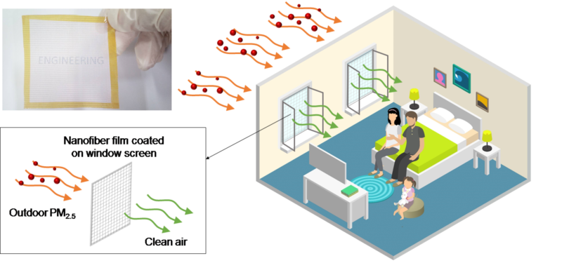
南京大学建筑与城市规划学院助理研究员施珊珊与香港中文大学助理教授陈淳、副教授张立合作,针对新近发展的纳米纤维薄膜纱窗对室内环境的影响展开研究,评估不同纳米纤维薄膜种类、使用策略对建筑室内PM2.5浓度及建筑通风的影响,可作为过滤应用纳米纤维薄膜进一步发展的指导参考。相关研究成果于11月发表在国际期刊《Indoor Air》上(Indoor Air, 2017, 27(6):1190-1200),系...


