搜索结果: 1-15 共查到“理学 Flood”相关记录227条 . 查询时间(0.734 秒)
Increased outburst flood hazard from Lake Palcacocha due to human-induced glacier retreat
Lake Palcacocha human-induced flood
2021/7/27
Human-induced warming is responsible for the retreat of Palcaraju glacier and the associated increase in glacial lake outburst flood hazard, according to an analysis of observations and numerical mode...

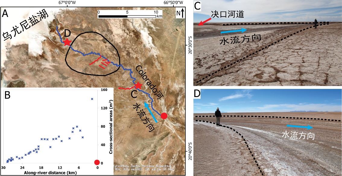
中国地质大学科学技术发展院李嘉光* 等,资源学院. Journal of Hydrology(2020), Digital Elevation Models for topographic characterisation and flood flow modelling along low-gradient, terminal dryland rivers: A comparison of spaceborne datasets for the Río Colorado, Bolivia(图)
精确表征;极低;缓河流;末端;地形;模拟河道;洪水;漫溢
2021/10/15
近日,国际知名期刊Journal of Hydrology在线刊发了中国地质大学资源学院李嘉光副教授团队在陆相湖盆边缘河流末端沉积体系研究的最新成果——Digital Elevation Models for topographic characterisation and flood flow modelling along low-gradient, terminal dryland rive...

By incorporating the architecture of city drainage systems and readings from flood gauges into a comprehensive statistical framework, researchers at Texas A&M University can now accurately p...
EXPERIMENTAL FLOOD EARLY WARNING SYSTEM IN PARTS OF BEAS BASIN USING INTEGRATION OF WEATHER FORECASTING, HYDROLOGICAL AND HYDRODYNAMIC MODELS
flood early warning WRF hydrological modelling hydrodynamic modelling flood inundation
2019/2/27
The flood early warning for any country is very important due to possible saving of human life, minimizing economic losses and devising mitigation strategies. The present work highlights the experimen...
COUPLING ANALYSIS OF HEAT ISLAND EFFECTS, VEGETATION COVERAGE AND URBAN FLOOD IN WUHAN
Heat Island Vegetation Coverage Urban Flood Change Detection Wuhan
2018/5/15
In this paper, satellite image, remote sensing technique and geographic information system technique are main technical bases. Spectral and other factors comprehensive analysis and visual interpretati...
FLASH FLOOD MAPPING FOR MOUNTAIN STREAMS USING HIGH-RESOLUTION ALOS-2 DATA
ALOS-2 Capacity building Flood detection Valley floodplain
2018/4/18
This paper introduces a practical way to improve the risk management capacity and resilience of communities by utilizing a prompt flash flood map produced from very high spatial resolution ALOS-2 data...
FLOOD VULNERABILITY REDUCTION, USING A PARTIAL PARTICIPATORY GIS APPROACH. A STUDY CASE IN BAJA CALIFORNIA SUR, MEXICO
Participatory cartography loods cyclones vulnerability reduction
2018/4/18
A partial participatory GIS approach was implemented in a community in La Paz, Baja California Sur, Mexico to reduce vulnerability of floods caused by cyclones. A workshop was held to locate areas sus...
POSSIBILITIES OF THE JOINT USE OF OPTICAL AND RADAR DATA IN FLOOD SPACE MONITORING
Remote Sensing Space Monitoring High Waters Flood Radar Data Radar Polarimetry
2018/4/18
The article gives a brief description of the system of space monitoring of high water and floods. Its main tasks are the operational dynamics of snow and ice cover melting and the passage of flood wat...
POSSIBILITIES OF THE JOINT USE OF OPTICAL AND RADAR DATA IN FLOOD SPACE MONITORING
Remote Sensing Space Monitoring High Waters Flood Radar Data Radar Polarimetry
2018/5/8
The article gives a brief description of the system of space monitoring of high water and floods. Its main tasks are the operational dynamics of snow and ice cover melting and the passage of flood wat...

Inland flood threat increasing in South Florida(图)
Inland flood threat increasing South Florida
2017/12/19
As South Florida raises groundwater levels to fight saltwater intrusion, the threat of inland flooding will only increase, according to newly published research results.Although high groundwater level...

Decade of data shows FEMA flood maps missed 3-in-4 claims(图)
Decade data FEMA flood maps missed 3-in-4 claims
2017/9/20
An analysis of flood claims in several southeast Houston suburbs from 1999 to 2009 found that the Federal Emergency Management Agency’s 100-year flood plain maps — the tool that U.S. officials use to ...
New Flood Study Reveals America’s Most Vulnerable Communities
New Flood Study America Most Vulnerable Communities
2017/7/24
Floods are the natural disaster that kill the most people. They are also the most common natural disaster. As the threat of flooding increases worldwide, a group of scientists at LSU have gathered val...
Study reveals America's most flood-vulnerable communities
America most flood-vulnerable communities
2017/7/24
Flooding is not only the most common natural disaster -- it's the natural disaster that kills the greatest number of people.As the threat of floods increases worldwide, scientists have been gathering ...
Rice U.’s Yellow River formula addresses flood risk,sustainability
Rice U.’s Yellow River flood risk sustainability
2017/7/20
U.S. and Chinese geologists studying China’s Yellow River have created a new tool that could help Chinese officials better predict and prevent the river’s all-too-frequent floods, which threaten as ma...
Flood threats changing across U.S.
Flood flooding flood risk National Weather Service rainfall climate Gabriele Villarini lihr–hydroscience and engineering NASA
2017/1/9
The risk of flooding in the United States is changing regionally, and the reasons could be shifting rainfall patterns and the amount of water in the ground.In a new study, University of Iowa engineers...

