
搜索结果: 1-15 共查到“aperture”相关记录98条 . 查询时间(0.398 秒)
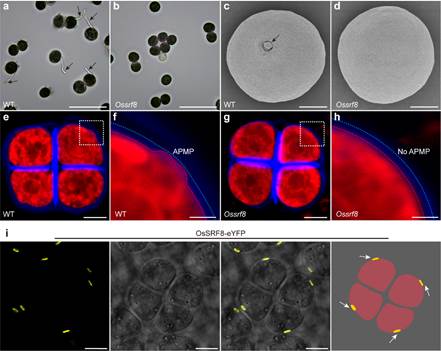
南京农业大学农学院《Nature Communications》发表万建民院士团队“OsSRF8 interacts with OsINP1 and OsDAF1 to regulate pollen aperture formation in rice”(图)
万建民 分子机制 基因 遗传
2024/6/11
2024年5月28日,南京农业大学万建民院士团队在Nature Communications在线发表了题为“OsSRF8 interacts with OsINP1 and OsDAF1 to regulate pollen aperture formation in rice”的研究论文,揭示了OsINP1-OsSRF8-OsDAF1分子模块调控水稻花粉萌发孔形成的分子机制。
GEOPHYSICAL PARAMETER RETRIEVAL FOR MICROWAVE C BAND SYNTHETIC APERTURE RADAR (SAR) DATASET USING INTEGRAL EQUATION MODEL
Microwave SAR Geophysical Parameters IEM Modelling
2019/2/28
The microwave remote sensing is highly useful, as it provides synoptic observation of the Earth’s surface or planetary bodies, regardless of day or night and the atmospheric conditions, propagation th...
FLOOD EXTENT MAPPING USING DUAL-POLARIMETRIC SENTINEL-1 SYNTHETIC APERTURE RADAR IMAGERY
Flood Polarimetry SAR Radar Harvey Sentinel-1
2018/5/14
Rapid generation of synthetic aperture radar (SAR) based flood extent maps provide valuable data in disaster response efforts thanks to the cloud penetrating ability of microwaves. We present a method...
EARTHQUAKE BUILDING DAMAGE MAPPING BASED ON FEATURE ANALYZING METHOD FROM SYNTHETIC APERTURE RADAR DATA
Building Damage Assessment Earthquake Emergency Feature Analysing SAR
2018/5/11
Playing an important role in gathering information of social infrastructure damage, Synthetic Aperture Radar (SAR) remote sensing is a useful tool for monitoring earthquake disasters. With the wide ap...
THE RESEARCH OF SPECTRAL RECONSTRUCTION FOR LARGE APERTURE STATIC IMAGING SPECTROMETER
Interference Imaging Spectroscopy Apodization Phase Correction Fourier Transform Spectral Reconstruction
2018/5/15
Imaging spectrometer obtains or indirectly obtains the spectral information of the ground surface feature while obtaining the target image, which makes the imaging spectroscopy has a prominent advanta...
STITCHING TYPE LARGE APERTURE DEPOLARIZER FOR GAS MONITORING IMAGING SPECTROMETER
Polarization Depolarizer Muller matrix Imaging Spectrometer Stitching Numerical Analysis
2018/5/15
To increase the accuracy of radiation measurement for gas monitoring imaging spectrometer, it is necessary to achieve high levels of depolarization of the incoming beam. The preferred method in space ...
GOLD MINERAL PROSPECTING USING PHASED ARRAY TYPE L-BAND SYNTHETIC APERTURE RADAR (PALSAR) SATELLITE REMOTE SENSING DATA,CENTRAL GOLD BELT,MALAYSIA
Gold prospecting PALSAR Bentong-Raub Suture Zone Peninsular Malaysia tropical environments
2016/11/30
The Bentong-Raub Suture Zone (BRSZ) of Peninsular Malaysia is one of the significant structural zones in Sundaland, Southeast Asia. It forms the boundary between the Gondwana-derived Sibumasu terrane ...
A FUZZY LOGIC-BASED APPROACH FOR THE DETECTION OF FLOODED VEGETATION BY MEANS OF SYNTHETIC APERTURE RADAR DATA
Fuzzy logic Flooded vegetation Synthetic Aperture Radar (SAR) Data fusion TerraSAR-X
2016/11/23
In this paper an algorithm designed to map flooded vegetation from synthetic aperture radar (SAR) imagery is introduced. The approach is based on fuzzy logic which enables to deal with the ambiguity o...
SYNTHETIC APERTURE RADAR (SAR) BASED CLASSIFIERS FOR LAND APPLICATIONS IN GERMANY
LBM-DE Land cover polarimetry SAR Sentinel-1 Sentinel-2
2016/7/5
Land cover information is essential for urban planning and for land cover change monitoring. This paper presents an overview of the work conducted at the Federal Agency for Cartography and Geodesy (BK...
EVALUATION DIGITAL ELEVATION MODEL GENERATED BY SYNTHETIC APERTURE RADAR DATA
Interferometry RADAR Digital Elevation Model European Space Agency Sentinel1-A Interferometry Wide Swath Synthetic Aperture Radar SAR DEM
2016/7/4
Digital elevation model, showing the physical and topographical situation of the earth, is defined a tree-dimensional digital model obtained from the elevation of the surface by using of selected an a...
MOBILE MAPPING BY FMCW SYNTHETIC APERTURE RADAR OPERATING AT 300 GHZ
Mobile Radar Mapping Car-borne SAR Street Mapping Ultra-High Resolution SAR Subcentimeter Resolution
2016/7/4
While optical cameras or laser systems are widely used for mobile mapping low attention was payed for radar systems. Due to new semiconductor technologies, compact and leight weight SAR systems based ...
Synthetic aperture radar data as a sustainable system for monitoring the Cropping system - an analysis
SAR ERS RADARSAT
2016/5/20
Satellite radar 4ata is of particll;lar interest for c r ~ p m o ~ t o r i ? g as the probability of obtaining
data from optical sensor dunng the growth penod of nee IS very low. At presen...
DETECTING GROUND SETTLEMENT OF SHANGHAI USING INTERFEROMETRIC SYNTHETIC APERTURE RADAR (INSAR) TECHNIQUES
Hazard Mapping Land Subsidence Deformation Analysis SAR InSAR DInSAR PSInSAR
2015/12/30
Differential (D) and persistent scatterer (PS) interferometric synthetic aperture radar (InSAR) (DInSAR and PSInSAR) techniques are arguably the most cost effective and efficient methods today for gro...
GEOREFERENCING ON SYNTHETIC APERTURE RADAR IMAGERY
The geometrical imaging image information image the shadow
2016/1/15
Due to the SAR1 geometry imaging, SAR images include geometric distortions that would be erroneous image information and the images should be geometrically calibrated. As the radar systems are side lo...
DETECTION OF BUILT-UP AREAS USING POLARIMETRIC SYNTHETIC APERTURE RADAR DATA AND HYPERSPECTRAL IMAGE
Polarimetric synthetic aperture radar polarimetric target decomposition hyperspectral image target detection correlation coefficient
2016/1/15
Polarimetric synthetic aperture radar (POLSAR) is an advantageous data for information extraction about objects and structures by using the wave scattering and polarization properties. Hyperspectral r...