搜索结果: 1-15 共查到“RGB-D”相关记录60条 . 查询时间(0.082 秒)
Assessment of an improved individual tree detection method based on local-maximum algorithm from unmanned aerial vehicle RGB imagery in overlapping canopy mountain forests
CROWN DETECTION POINT CLOUDS UAV IMAGERY SEGMENTATION DELINEATION LIDAR INVENTORY HEIGHT FIELD
2023/12/15
Low consumer-grade cameras attached to small unmanned aerial vehicles (UAV) can easily acquire high spatial resolution images, leading to convenient forest monitoring at small-scales for forest manage...
PLVO: 基于平面和直线融合的RGB-D视觉里程计
RGB-D视觉里程计 平面− 直线融合 机器人定位 自适应融合 多特征联合关联
2024/1/16
针对利用平面特征计算RGB-D相机位姿时的求解退化问题,提出平面和直线融合的RGB-D视觉里程计(Plane-line-based RGB-D visual odometry,PLVO).首先,提出基于平面−直线混合关联图(Plane-line hybrid association graph,PLHAG)的多特征关联方法,充分考虑平面和平面、平面和直线之间的几何关系,对平面和直线两类...

Estimation of Plant Height and Aboveground Biomass of Toona sinensis under Drought Stress Using RGB-D Imaging
Plant Height Aboveground Biomass Toona sinensis
2023/6/2
2020年7月31日,国家知识产权局公开一件由贵州省烟草科学研究院和华南农业大学共同申请的发明专利:基于RGB值测定烟叶烘烤变黄变褐程度的方法、系统及装置。该发明公开了一种基于RGB值测定烟叶烘烤变黄变褐程度的方法、系统及装置,所述方法包括:S1、获取烘烤的烟叶图像,所述烟叶图像为去除背景色的图像;S2、判断所述烟叶图像中每个像素点的颜色并计数,所述每个像素点的颜色区分为黄色、绿色和褐色;S3、计...
AGB Estimation in a Tropical Mountain Forest (TMF) by Means of RGB and Multispectral Images Using an Unmanned Aerial Vehicle (UAV)
forest AGB UAV RGB data multispectral data
2024/2/4
The present investigation evaluates the accuracy of estimating above-ground biomass (AGB) by means of two different sensors installed onboard an unmanned aerial vehicle (UAV) platform (DJI Inspire I) ...
近日,我校作物表型组学团队成功自主研发一套高通量CT-RGB双模式成像系统,结合水稻核心种质资源和全基因组关联分析在水稻分蘖遗传研究方面获得新进展,相关成果以“Combining high-throughput micro-CT-RGB phenotyping and genome-wideassociation study to dissect the genetic architecture ...

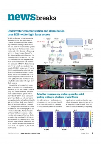
近日,信息科学与工程学院副教授田朋飞研究团队在基于RGB激光白光光源的水下通信和照明领域取得新进展。相关研究成果以《基于激光白光光源的高速水下无线光通信和高效率水下照明》(Laser-based white-light source for high-speed underwater wireless optical communication and high-efficiency underw...
INTEGRATING DEPTH AND IMAGE SEQUENCES FOR PLANETARY ROVER MAPPING USING RGB-D SENSOR
RGB-D camera Depth Planetary Rover Mapping Bundle Adjustment Point Cloud
2018/5/15
RGB-D camera allows the capture of depth and color information at high data rates, and this makes it possible and beneficial integrate depth and image sequences for planetary rover mapping. The propos...
EVALUATION OF RGB-BASED VEGETATION INDICES FROM UAV IMAGERY TO ESTIMATE FORAGE YIELD IN GRASSLAND
RGB vegetation indices unmanned aerial vehicle biomass yield grassland pasture
2018/5/15
Monitoring forage yield throughout the growing season is of key importance to support management decisions on grasslands/pastures. Especially on intensely managed grasslands, where nitrogen fertilizer...
COMPARISON BETWEEN RGB AND RGB-D CAMERAS FOR SUPPORTING LOW-COST GNSS URBAN NAVIGATION
Urban Navigation Relative Orientation Kalman filter RGB-D Kinect GNSS Low-cost
2018/6/5
A pure GNSS navigation is often unreliable in urban areas because of the presence of obstructions, thus preventing a correct reception of the satellite signal. The bridging between GNSS outages, as we...
基于混合卷积自编码极限学习机的RGB-D物体识别
极限学习机 卷积神经网络 自编码极限学习机 物体识别
2018/3/7
有效学习丰富的表征信息在RGB-D目标识别任务中至关重要,是实现高泛化性能的关键。针对卷积神经网络训练时间长的问题,提出了一种混合卷积自编码极限学习机(HCAE-ELM)结构,包括卷积神经网络(CNN)和自编码极限学习机(AE-ELM),该结构合并了CNN的有效性和AE-ELM快速性的优点。它使用卷积层和池化层分别从RGB和深度图来有效提取低阶特征,然后在共享层合并两种模型特征,输入到自编码极限学...
基于RGB通道下模糊核估计的图像去模糊
模糊核估计 RGB通道 组稀疏 图像去模糊
2018/6/11
图像去模糊旨在从受损图像中恢复出清晰图像。由于模糊过程未知,精确地估计出模糊核函数,成为得到
清晰复原图像的关键。对于彩色图像来讲,现存的方法只考虑在灰度域估计模糊核。事实上,各个通道的色彩分
量图所受到的模糊核函数的影响是不同的。为此,提出一种获得更加精确的模糊核的方法,利用彩色图像的 3个
色彩通道(RGBchannels)代替灰度域分别进行模糊核估计,并将估计出的模糊核应用到基于细稀疏...
提出了一种基于RGB-D信息的移动机器人自主探索与地图构建方法.首先,基于RGB-D传感器提供的信息,通过定位点生成、地图构建与闭环检测,实时构建3D点云地图.然后,将探索过程描述成部分可观测马尔可夫决策过程,结合局部地图推演策略与全局边界搜索策略,建立了移动机器人的自主探索方法.在此基础上,确定移动机器人当前动作约束,采用动态窗运动控制方法,既能避免移动机器人陷入局部最优,又能保证采用RGB-D...


