搜索结果: 1-15 共查到“工学 Sites”相关记录140条 . 查询时间(0.14 秒)


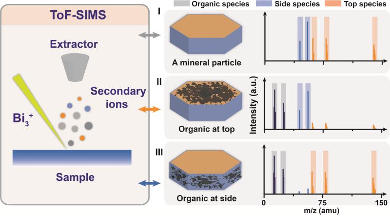
中国地质大学科学技术发展院黄柳琴,蒋宏忱*等,BGEG国家重点实验室,Environmental Science & Technology (2021),Molecular determination of organic adsorption sites on smectite during Fe-redox processes using ToF-SIMS analysis(图)
环境科学;二次;离子;质谱;蒙脱石;结构
2021/10/14
近日,环境科学领域Nature Index期刊 《Environmental Science & Technology》刊发中国地质大学生物地质与环境地质国家重点实验室黄柳琴老师为第一作者、蒋宏忱教授为第一通讯作者的学术论文——利用飞行时间-二次离子质谱对蒙脱石结构铁氧化还原过程中有机质吸附位点的分子鉴定 ,美国西北太平洋国家实验室朱梓华研究员为共同通讯作者。
A COMBINED APPROACH FOR SURVEYING COMPLEX COASTAL SITES
Coastal Sites Mobile Mapping System 3D Laser Scanner
2019/3/2
This study presents an integrated approach for reading coastal sites. A process aimed at protecting and enhancing these sites must be developed alongside a targeted interdisciplinary strategy, closely...
IMPACT ASSESSMENT OF MIKANIA MICRANTHA ON LAND COVER AND MAXENT MODELING TO PREDICT ITS POTENTIAL INVASION SITES
Mikania micrantha Invasive Species Chitwan National Park Image Classification Maxent Modeling
2017/7/12
Mikania micrantha is one of the major invasive alien plant species in tropical moist forest regions of Asia including Nepal. Recently, this weed is spreading at an alarming rate in Chitwan National Pa...
NON-DESTRUCTIVE SURVEY OF ARCHAEOLOGICAL SITES USING AIRBORNE LASER SCANNING AND GEOPHYSICAL APPLICATIONS
Airborne laser scanning (ALS) Georadar (GPR) Radkov Archaeological survey Land survey mapping Geographical information system (GIS) Georeferencing
2016/11/11
This paper deals with the non-destructive documentation of the “Radkov” (Svitavy district, Czech Republic) archaeological site. ALS, GPR and land survey mapping will be used for the analysis. The fort...
USING REMOTELY SENSED DATA FOR DOCUMENTATION OF ARCHAEOLOGICAL SITES IN NORTHEASTERN MESOPOTAMIA
Mesopotamia Archaeology MULINEM Remote Sensing Arbíl Makhmúr al-Quadíma Al-Hadítha
2016/11/11
This paper introduces two archaeological sites documented during the MULINEM (The Medieval Urban Landscape in Northeastern Mesopotamia) project. This project investigates the Late Sasanian and Islamic...
KNOWLEDGE AND VALORIZATION OF HISTORICAL SITES THROUGH 3D DOCUMENTATION AND MODELING
Cultural Heritage Documentation 3D Reconstruction 3D Modeling Visualization Virtual Tour
2016/11/11
The paper presents the first results of an interdisciplinary project related to the 3D documentation, dissemination, valorization and digital access of archeological sites. Beside the mere 3D document...
AUTOMATIC DAMAGE DETECTION FOR SENSITIVE CULTURAL HERITAGE SITES
Cultural heritage change detection
2016/11/11
The intentional damages to local Cultural Heritage sites carried out in recent months by the Islamic State (IS) have received wide coverage from the media worldwide. Earth Observation data is an impor...
BUDGET UAV SYSTEMS FOR THE PROSPECTION OF SMALL-AND MEDIUM-SCALE ARCHAEOLOGICAL SITES
Archaeology Photogrammetry UAV UAS Unmanned Aerial Vehicles Platforms Mission Planning Mapping
2016/7/5
One of the popular uses of UAVs in photogrammetry is providing an archaeological documentation. A wide offer of low-cost (consumer) grade UAVs, as well as the popularity of user-friendly photogrammetr...
EVALUATION OF THE MAIN CEOS PSEUDO CALIBRATION SITES USING MODIS BRDF/ALBEDO PRODUCTS
Satellites Calibration Multi-Spectral BRDF/Albedo MODIS
2016/7/4
This work describes our findings about an evaluation of the stability and the consistency of twenty primary PICSs (Pseudo-Invariant Calibration Sites). We present an analysis of 13 years of 8-daily MO...
Constructing Shale Gas Sites
Shale Gas Sites
2016/6/12
Extracting gas from shale rock not only causes environmental disturbances below ground, the surface infrastructure required to drill the wells can cause a variety of problems above ground, from fragme...
Air Ion Variation at Poultry-farm, Coastal, Mountain, Rural and Urban Sites in India
Pollution index Aerosol Air ion Transpiration Meteorological Parameters
2016/3/25
The air ions are continuously generated and destroyed by various processes in the atmosphere. Near the surface, the nature
of ions is very complex and they show large variations in their physical pro...
SPECTRO-DIRECTIONAL CHRIS/PROBA DATA OVER TWO SWISS TEST SITES FOR IMPROVED ESTIMATION OF BIOPHYSICAL AND–CHEMICAL VARIABLES–FIVE YEARS OF ACTIVITIES
Ecosystem Hyperspectral Vegetation Modelling Monitoring Retrieval Spectral Observations
2015/12/30
The spaceborne ESA-mission CHRIS (Compact High Resolution Imaging Spectrometer) on-board PROBA-1 (Project for On-board Autonomy) delivers multi-directional data sets that contain spectral, directional...
EARTH OBSERVATION FROM SPACE FOR THE PROTECTION OF UNESCO WORLD HERITAGE SITES:DLR ASSISTING UNESCO
Remote Sensing Cultural Heritage Archaeology Monitoring SAR Satellite
2015/12/28
The United Nations Educational, Scientific and Cultural Organization (UNESCO) has established an operational network of space partners with key space agencies, space research institutions and universi...


