搜索结果: 1-12 共查到“工学 Icesat”相关记录12条 . 查询时间(0.078 秒)

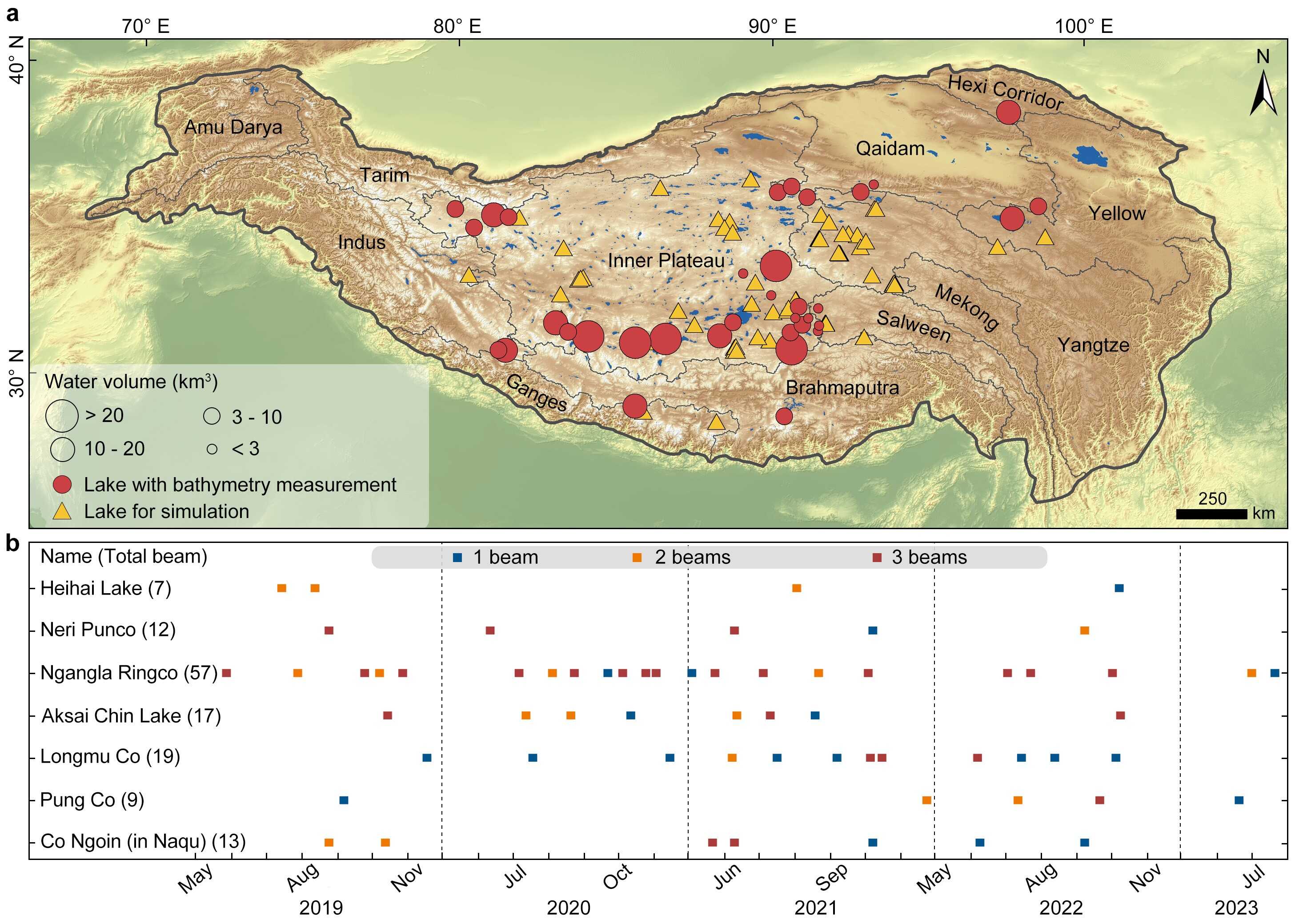
中国科学院青藏高原研究所基于ICESat-2激光雷达高度计数据的青藏高原湖泊水储量估算(图)
激光 数据 测量
2024/11/6
青藏高原湖泊数量众多且分布密集,是“亚洲水塔”的重要组成部分。受限于青藏高原环境恶劣,湖泊的水下地形测量数据较少被公开,对高原湖泊水储量及其变化的准确估算有一定影响。尽管激光雷达的穿透特性已被广泛应用于重建滨海水下地形等领域,但由于穿透深度浅、水下光子提取困难、湖泊水质复杂等难题,限制了激光雷达在重建湖泊水下地形的应用。

2021年11月30日下午,由山东科技大学研究生会学术科技部主办,测绘与空间信息学院承办的第1034期研究生讲坛在J6楼434报告厅成功举办。测绘与空间信息学院研究生孟文君作了题为“基于ICESat-2卫星激光数据的岛礁周边水深探测研究”的专题讲座,学院相关专业老师和同学参会。
DECOMPOSITION TECHNIQUES FOR ICESAT/GLAS FULL-WAVEFORM DATA
ICESat/GLAS Full-Waveform Waveform Decomposition Method Overlapped Echo Components Levenberg-Marquard (LM) Optimization Method
2018/5/15
The geoscience laser altimeter system (GLAS) on the board Ice, Cloud, and land Elevation Satellite (ICESat), is the first long-duration space borne full-waveform LiDAR for measuring the topography of ...
VERTICAL ACCURACY ASSESSMENT OF ZY-3 DIGITAL SURFACE MODEL USING ICESAT/GLAS LASER ALTIMETER DATA
Accuracy assessment ZY-3 stereo images DSM ICESat/GLAS
2017/7/12
The Ziyuan-3 (ZY-3) satellite, as the first civilian high resolution surveying and mapping satellite in China, has a very important role in national 1 : 50,000 stereo mapping project. High...
ANTARCTIC ICE SHEET SURFACE MASS BALANCE ESTIMATES FROM 2003 TO 2015 USING ICESAT AND CRYOSAT-2 DATA
Antarctica Mass Balance ICESat CryoSat-2
2016/11/30
An assessment of Antarctic ice sheet surface mass balance from 2003 to 2015 has been carried out using a combination of ICESat data from 2003 to 2009 and CryoSat-2 data from 2010 to 2015. Both data se...
ESTIMATION OF REGIONAL FOREST ABOVEGROUND BIOMASS COMBINING ICESAT-GLAS WAVEFORMS AND HJ-1A/HSI HYPERSPECTRAL IMAGERIES
LiDAR ICESat-GLAS Waveform HJ-1A/HSI Hyperspectral imagery Forest aboveground biomass Support vector machines
2016/11/24
Estimation of forest aboveground biomass (AGB) is a critical challenge for understanding the global carbon cycle because it dominates the dynamics of the terrestrial carbon cycle. Light Detection and ...
ICESAT VALIDATION OF TANDEM-X I-DEMS OVER THE UK
Global DEM validation TanDEM-X intermediate DEM ICESat elevations
2016/11/8
From the latest TanDEM-X mission (bistatic X-Band interferometric SAR), globally consistent Digital Elevation Model (DEM) will be available from 2017, but their accuracy has not yet been fully charact...
EVALUATION OF ASTER GDEM V3 USING ICESAT LASER ALTIMETRY
ASTER ICESat Topography Elevation Models Geodetic Ground Control Laser Altimetry
2016/11/8
We have used a set of Ground Control Points (GCPs) derived from altimetry measurements from the Ice, Cloud and land Elevation Satellite (ICESat) to evaluate the quality of the 30 m posting ASTER (Adva...
IMPROVE THE ZY-3 HEIGHT ACCURACY USING ICESAT/GLAS LASER ALTIMETER DATA
ZY-3 ICESat GLAS Satellite Laser Altimetry Satellite LiDAR
2016/7/4
ZY-3 is the first civilian high resolution stereo mapping satellite, which has been launched on 9th, Jan, 2012. The aim of ZY-3 satellite is to obtain high resolution stereo images and support the 1:5...
TEMPERATE FOREST HEIGHT ESTIMATION PERFORMANCE USING ICESAT GLAS DATA FROM DIFFERENT OBSERVATION PERIODS
Temperate Forest Height Large Footprint Lidar waveform ICEsat GLAS Observation Period
2015/12/31
To investigate the forest height estimation potential and performance of different observation periods GLAS data in temperate region, this study uses the Northeast of China as test site. USFS FIA styl...
ICESAT FULL WAVEFORM ALTIMETRY COMPARED TO AIRBORNE LASER ALTIMETRY OVER THE NETHERLANDS
Full waveform DTM AHN Laser altimetry ICESat
2015/11/10
Since 2003 the spaceborne laser altimetry system on board of NASA’s Ice, Cloud and land Elevation Satellite (ICESat) has acquired a large world-wide database of full waveform data organized in 15 prod...
为了更好地保证从中山站到Dome A的南极内陆冰盖考察, 该考察路线沿线的地形信息是必需的. 虽然Radarsat南极制图计划(RAMP)能提供迄今为止最高精度的全南极数字高程模型(DEM), 其最高水平分辨率为200 m, 但其真正的水平分辨率根据源数据的比例尺和区域覆盖密度不同而不同. 对于冰架和内陆冰盖地区, 水平精度约为5 km. 在东南极内陆冰盖地区和远离山脉地区该DEM的垂直精度估计...

