
ЫбЫїНсЙћ: 1-15 ЙВВщЕНЁАРэбЇ SatelliteЁБЯрЙиМЧТМ388Ьѕ . ВщбЏЪБМф(0.492 Уы)
Global satellite data shows clouds will amplify global heating
cloud global heating satellite measurements
2021/8/3
A new approach to analyse satellite measurements of Earth's cloud cover reveals that clouds are very likely to enhance global heating.
ALGORITHM AND APPLICATION OF GCP-INDEPENDENT BLOCK ADJUSTMENT FOR SUPER LARGE-SCALE DOMESTIC HIGH RESOLUTION OPTICAL SATELLITE IMAGERY
Rational Function Model (RFM) Virtual Control Points Least-squares Block Adjustment Alternating Direction Method Geometric Constraints of Horizontal and Vertical
2018/5/15
The accurate positioning of optical satellite image without control is the precondition for remote sensing application and small/medium scale mapping in large abroad areas or with large-scale images. ...
HOW WELL DOES SATELLITE FINE MODE AEROSOL PRODUCT VALIDATE WITH GROUND-BASED MEASUREMENTS FOR MODIS AND HIMAWARI-8?
MODIS Himawari-8 AERONET fine mode aerosol fine mode fraction
2018/5/14
Currently, the validation of MODIS and Himawari-8 aerosol products mostly focuses on AOD, but the validation of their fine mode aerosol data is limited. In this paper, 22 AERONET sites in Asia from 20...
INTEGRATION OF SATELLITE, GLOBAL REANALYSIS DATA AND MACROSCALE HYDROLOGICAL MODEL FOR DROUGHT ASSESSMENT IN SUB-TROPICAL REGION OF INDIA
VIC Soil Moisture Agricultural drought SMDI CCI
2018/5/15
Change in soil moisture regime is highly relevant for agricultural drought, which can be best analyzed in terms of Soil Moisture Deficit Index (SMDI). A macroscale hydrological model Variable Infiltra...
BASELINE ERROR ANALYSIS AND EXPERIMENTAL VALIDATION FOR HEIGHT MEASUREMENT OF FORMATION INSAR SATELLITE
InSAR Height Measurement Baseline Error DEM Simulation Validation SRTM TerraSAR-X/TanDEM-X
2018/5/14
In this paper, we proposed the stochastic model of InSAR height measurement by considering the interferometric geometry of InSAR height measurement. The model directly described the relationship betwe...
RECENT SEA LEVEL CHANGES IN THE BLACK SEA FROM SATELLITE GRAVITY AND ALTIMETER MESUREMENTS
Black Sea Sea Level Change Altimetry GRACE
2018/4/18
Sea level rise causes devastating effects on coastal habitats. For example, coastal erosion and saltwater intrusion are major threats for the Black Sea coasts. So, determining sea level changes in the...
RECENT SEA LEVEL CHANGES IN THE BLACK SEA FROM SATELLITE GRAVITY AND ALTIMETER MESUREMENTS
Black Sea Sea Level Change Altimetry GRACE
2018/5/8
Sea level rise causes devastating effects on coastal habitats. For example, coastal erosion and saltwater intrusion are major threats for the Black Sea coasts. So, determining sea level changes in the...
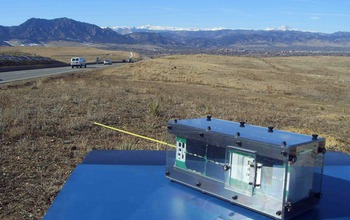
Six-Decade-Old Space Mystery Solved With Shoebox-Sized Satellite Called A CubeSatЃЈЭМЃЉ
Six Decade Old Space Mystery Shoebox-Sized Satellite CubeSat
2017/12/19
A 60-year-old mystery about the source of energetic, potentially damaging particles in Earth's radiation belts has been solved using data from a shoebox-sized satellite built and operated by students....
How satellite data led to a breakthrough for Lake Erie toxic algal blooms
satellite data Lake Erie toxic algal blooms
2017/7/20
With the growing frequency and magnitude of toxic freshwater algal blooms becoming an increasingly worrisome public health concern, Carnegie scientists Jeff Ho and Anna Michalak, along with colleagues...
ACCELERATION OF SEA LEVEL RISE OVER MALAYSIAN SEAS FROM SATELLITE ALTIMETER
Climate Change Sea Level Rise Satellite Altimeter
2016/10/14
Sea level rise becomes our concern nowadays as a result of variously contribution of climate change that cause by the anthropogenic effects. Global sea levels have been rising through the past century...
MEAN SEA SURFACE (MSS) MODEL DETERMINATION FOR MALAYSIAN SEAS USING MULTI-MISSION SATELLITE ALTIMETER
Sea Surface Height Mean Sea Surface RADS Satellite Altimeter
2016/10/14
The advancement of satellite altimeter technology has generated many evolutions to oceanographic and geophysical studies. A multi-mission satellite altimeter consists with TOPEX, Jason-1 and Jason-2, ...
APPLICATION OF MULTISPECTRAL SATELLITE DATA FOR GEOLOGICAL MAPPING IN ANTARCTIC ENVIRONMENTS
Multispectral satellite data Geological mapping Antarctic environments
2016/10/14
Remote sensing imagery is capable to provide a solution to overcome the difficulties associated with geological field mapping in the Antarctic. Advanced optical and radar satellite imagery is the most...
FOREST COVER MAPPING IN ISKANDAR MALAYSIA USING SATELLITE DATA
Forest Cover Deforestation Distubance CLASlite Remote Sensing Malaysia
2016/10/14
Malaysia is the third largest country in the world that had lost forest cover. Therefore, timely information on forest cover is required to help the government to ensure that the remaining forest reso...
2nd International Workshop on China Seismo-Electromagnetic Satellite Mission
electromagnetic waves seismo-ionospheric perturbations,
2016/7/27
China Seismo-Electromagnetic Satellite (CSES) is the first space-based observational platform in the strategic plan of China earthquake stereoscopic observation system, and the first satellite of spac...
Spin-up of rubble-pile asteroids:Disruption,satellite formation,and equilibrium shapes
Asteroid, Dynamics Rotational dynamics Satellites,Dynamics
2015/12/25
We present results from numerical experiments testing the behavior of cohesionless gravitational aggregates experiencing a gradual increase of angular momentum. The test bodies used in these numerical...
жаЙњбаОПЩњНЬг§ХХааАё-Ьѕ
- е§дкМгди...
жаЙњбЇЪѕЦкПЏХХааАё-Ьѕ
- е§дкМгди...
ЪРНчДѓбЇПЦбаЛњЙЙХХааАё-Ьѕ
- е§дкМгди...
жаЙњДѓбЇХХааАё-Ьѕ
- е§дкМгди...
ШЫЁЁЮя-ЦЊ
- е§дкМгди...
ПЮЁЁМў-ЦЊ
- е§дкМгди...
ЪгЬ§зЪСЯ-ЦЊ
- е§дкМгди...
баеазЪСЯ -ЦЊ
- е§дкМгди...
жЊЪЖвЊЮХ-ЦЊ
- е§дкМгди...
ЙњМЪЖЏЬЌ-ЦЊ
- е§дкМгди...
ЛсвщжааФ-ЦЊ
- е§дкМгди...
бЇЪѕжИФЯ-ЦЊ
- е§дкМгди...
бЇЪѕеОЕу-ЦЊ
- е§дкМгди...